


Typhoon Podul is likely to bring downpours and thunderstorms to the city, the Hong Kong Observatory said.
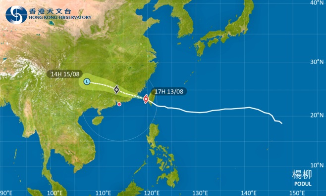
"Podul is moving across the Taiwan Strait. It is expected to maintain a distance of about 400 kilometres or more from Hong Kong [on Wednesday]," it said.
"According to the present forecast track, Podul will make landfall again in the vicinity of southern Fujian overnight.
"It will then move across inland Guangdong and weaken progressively [on Thursday] but will also be relatively closer to the vicinity of the Pearl River Estuary at the same time."
The weather forecaster also said it would assess the need to upgrade the Standby Signal No 1, issued at 8.40am, to a No 3 warning later.
"Locally, there will be heavy squally showers and thunderstorms [on Thursday]. Showers will be more frequent in some areas at first," it said.
"Depending on the weakening rate of Podul, its distance from the Pearl River Estuary and the change in local winds, the observatory will assess the need to issue the Strong Wind Signal No 3 [on Thursday morning]."
The Airport Authority said a total of 17 flights had been cancelled as of 2.30pm – nine between Hong Kong and Kaohsiung and eight between the SAR and Taipei.
The storm earlier made landfall in southeastern Taiwan.
Wet spell looms as typhoon heads for second landfall
2025-08-13 HKT 17:25
Share this story


