


The Strong Wind Signal No 3 will be issued between 9am and 11am on Friday, according to the Observatory, as an intensifying storm approaches Hong Kong
The Education Bureau announced the suspension of certain classes as a result.
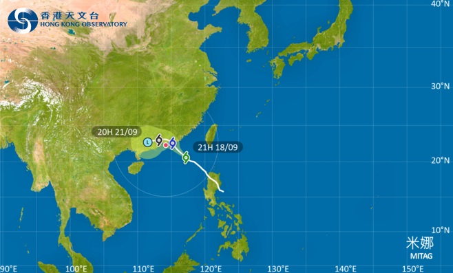
According to the Observatory, Tropical Storm Mitag is expected to make landfall over the coast of eastern Guangdong from later on Friday to early Saturday, while it gradually turns to a westerly track to move closer to the vicinity of the Pearl River Estuary under the influence of the northeast monsoon.
"However, there are uncertainties in its landfall location and intensity. Depending on the change in Mitag's intensity, the distance of its gale winds from Hong Kong and the change in local wind condition, the Observatory will then assess the need of issuing higher tropical cyclone warning signals," it said.
The Education Bureau announced the suspension of kindergartens, schools for children with physical disability as well as schools for children with intellectual disability on Friday.
Occasional strong winds are set to begin affecting offshore waters and high ground in the city, and showers are expected to increase gradually on Friday.
The No 1 signal was issued at 9.20pm on Wednesday.
The forecaster, separately, warned of an incoming storm east of the Philippines named Ragasa.
"According to the present forecast, Ragasa will intensify significantly and move towards the vicinity of Luzon Strait in the next few days, and it may reach super typhoon intensity," it said.
"It will enter the northern part of the South China Sea early next week, and then edge closer to the coast of southern China."
T3 to be issued between 9am and 11am on Friday
2025-09-18 HKT 22:07
Share this story


