


The observatory issued the Standby Signal No. 1 at 12.20pm on Monday as Typhoon Fung-wong continued edging closer to Hong Kong.
Forecasters said the No. 1 signal will remain in force until at least noon on Tuesday.
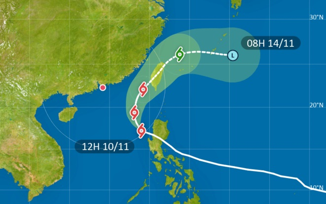
According to the current forecast, the storm will take a more northerly track towards Taiwan, and is expected to remain 400km or more from Hong Kong at its closest point – either on Tuesday night or early on Wednesday.
“Depending on the change in intensity of Fung-wong, its distance from Hong Kong and local wind conditions, the Observatory will assess the need for issuing the Strong Wind Signal, No.3,” the observatory said in a statement.
The forecaster said under the combined effect of Fung-wong and the northeast monsoon, it will be windy and slightly cooler with swells over the coast of Guangdong in the next couple of days.
It warned that minor flooding may occur over some low-lying coastal areas on Monday night and early on Tuesday morning.
Temperatures in Hong Kong’s urban areas are expected to fall to around 20 degrees midweek.
Lui Yuk-sing, an acting senior scientific officer at the observatory, said late-season typhoons have become more common in recent years, due in part to warmer seas.
"As we enter November, prevailing winds along coastal areas become dominated by the northeast monsoon," Lui told an RTHK programme.
"But when certain conditions are met – such as relatively warm temperatures at the sea surface, or when steering currents create a storm-friendly environment – there is a chance for a tropical cyclone to form, and even enter the South China Sea."
Hong Kong saw three tropical storms in November last year, with the forecaster issuing the No. 8 signal for more than 11 hours when Toraji approached the city.
T1 to stay in effect until at least noon Tuesday
2025-11-10 HKT 12:25
Share this story


