


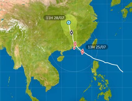
The Observatory says it will assess the need to raise higher tropical cyclone warning signals between 9 pm and midnight, as Typhoon Noul heads towards the coastal areas of Guangdong.
It made the announcement shortly after issuing the Strong Wind Signal No 3 at 1.20 pm.
According to the present forecast track, Noul is still expected to make landfall somewhere between Huizhou and Shanwei on Sunday morning, when it will skirt around 100 kilometres north-east of Hong Kong.
Winds over parts of Hong Kong are expected to reach gale force.
Under the influence of the rainbands of Noul, there will be frequent heavy squally showers and thunderstorms on Sunday.
Rainstorm warning signals or localised heavy rain advisories may need to be issued by then.
People are advised to stay away from the shoreline and not engage in water sports as there will be swells.
Edited by Robert Kemp
HKO to consider higher signals between 9 pm and 12 am
2026-07-25 HKT 13:44
Share this story


