


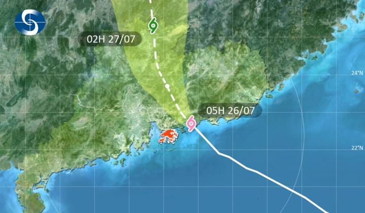
The Hong Kong Observatory (HKO) on Sunday said it will downgrade the T9 signal at 7.10 am – six hours after it was issued – as Typhoon Noul continues to weaken as it starts moving away from Hong Kong.
It had made landfall as a severe typhoon around Huizhou city early on Sunday morning before weakening. It had passed around 80 kilometres northeast of Hong Kong at its closest point.
While the storm is expected to continue to weaken as it moves further inland in Guangdong, the observatory warned that gales are still affecting many places with occasional storm force winds offshore and over high ground.
"Local winds are expected to become southwesterlies gradually," the HKO said in a statement. "Areas which were previously sheltered may become exposed.
"Seas will be high with swells. Members of the public should remain on the alert," it warned.
The Amber Rainstorm Warning was issued at 5am as the storm dumped around 30 millimetres of rain within an hour over the eastern part of the New Territories.
Sustained winds of 97 km/h were recorded at Tate’s Cairn at one point, while gusts of up to 131 km/h were seen in Cheung Chau.
The MTR Corporation said all open sections of its railway lines will be suspended while the T9 warning is in force.
Other services will run at reduced intervals of around 15 minutes between trains.
The Education Bureau said classes of all day schools will be suspended for the day. Arrangements for evening schools will be announced later.
The last time the observatory issued the T9 warning was in September 2025 during the passage of Super Typhoon Ragasa.
_____________________________
Last updated: 2026-07-26 HKT 06:00
Edited by Cecil Wong
T9 signal to be downgraded to T8 at 7.10am
2026-07-26 HKT 05:14
Share this story


